Navigation routes on the Lijiang River, a favorite scenic area in Guilin, Guangxi Zhuang Autonomous Region, had to be changed on Wednesday owing to a dramatic fall in the water level, according to the local tourism department.
Water flow on the Lijiang has fallen to just 20.3 cubic meters per second, far below the 30 cubic meters per second required for normal navigation of pleasure boats.
With the change of the route, more boats will be used in shallow waters and all scenic sites will remain open to visitors.
The tourism department reported that the drop in water level resulted from a month of dry weather. But it was not only the lack of rainfall that caused the Lijiang to run dry, according to water conservancy and forestry experts.
Since the latter half of the 1990s, dry-season suspension of navigation has been extended for as much as three months.
On January 9 this year, the flow rate dove to only 8.5 cubic meters per second, according to the River Condition Department of the Guilin Hydrology Monitoring Station.
Forest coverage on the Mao'er Mountains, the river's source, fell steadily from the 1950s to the 1990s. Forested area, which accounted for some 40,000 hectares in 1958, had plummeted to 17,700 hectares by 1980. Reforestation projects in the following decade brought the figure back up to 30,800 hectares, but the new tree coverage cannot undo all the damage that was done.
Excessive and poorly planned development of the tourism industry is another factor, experts said.
In recent years, the plethora of restaurants and inns and newly developed scenic spots draw fresh water from the river and dump trash and untreated sewage back into it.
The 437-kilometer-long Lijiang, a branch of the Pearl River, runs from the Mao'er Mountains north of Guilin through Yangshuo and Pinle to Wuzhou, where it joins the Xijiang River.
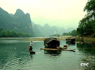
A trip along the Lijiang has long been considered one of the highlights of a holiday in China. From Guilin to Yangshuo, the river meanders through 83 kilometers of beautiful countryside, with bamboo forests, dense reed-beds and spectacular karst rock formations.
(China.org.cn, Xinhua News Agency December 16, 2004)