| Home / Living in China / Expat Tales | Tools: Save | Print | E-mail | Most Read |
| The Wall of Two Williams |
| Adjust font size: |
By Willian Lindesay
I first got to know William Edgar Geil not through conscious re-photography, but via coincidental re-photography. He hailed from
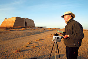
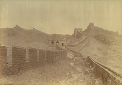
William Lindesay focuses his lens on Yumenguan (Jade Gate) in Geil's book was sent to me by Mrs Marjories Hessel-Tiltman, who heard me speaking about my own Great Wall experiences on a BBC radio broadcast in 1990. "It's probably too late to be of use," she wrote of her gift to me. But destiny was to prove otherwise. Thumbing through The Great Wall of China I was amazed by the quality of William Geil's photographs, and curious to see that one photograph was strangely familiar. It depicted a remote section of the fortifications in There we were, two Williams, 80 years apart, taking photographs of the same view, with William senior and William junior both in frame. Geil sat, wearing a pith helmet, I walked, donning a fur army hat. Only then did I realize what was markedly different. A watchtower in the center of Geil's photograph had disappeared. Thrill turned to despair. It took me some time to realize how I could use photographs taken by Geil and other explorers and photographers, beyond their nostalgic curiosity value and within a conservation offensive. I admired Geil's purity of purpose: To understand the Great Wall by investigating its full-length condition. I pondered how it largely survived intact until the last century, only to suffer immensely. What would the next century have in store? I only hoped that a broad "re-photography" study of the Great Wall might help influence a better future.
William Edgar Geil, a missionary explorer from the
Inspired to explore the Great Wall from boyhood after seeing it marked in my Oxford School Atlas, I eventually trekked for 78 days during 1987 between its western and eastern ends, but for half of the time never saw any Great Wall. I had traveled in the immediate aftermath of a period of intense desecration (1950s to 1970s) that counterbalanced the frenetic construction of the Wall in the mid-late 1500s. By 2004 my archive of vintage photographs consisted of more than 400 images. I chose about 80 of the most interesting, and placed them in geographical running order from west to east across the floor of my study: starting on the left with Yumenguan (The Jade Gate) and stretching 6 meters to the right, ending at Old Dragon's Head in Shanhaiguan. Assault of nature At Jiayuguan, the western terminus of the Ming Wall, I met Li Xiaofeng, curator of the This tower was as important as Old Dragon's Head, where the Wall meets the sea. I nicknamed it the "Dragon's tail". Geil described his journey out there in August 1908: "We took mules and visited the real end of the Great Wall, which is not Kaiyukwan itself, but a point fifteen li southwest of it. The construction does not abut the southern mountains, but stops short on a precipice sheer down two hundred feet, as perpendicular as if cut by engineers with a plumb line. Mr Clark dropped a stone and his heart beat eight times before we heard it splash into the water below."
This photo taken by William Edgar Geil in 1907-08 shows the Badaling section of the Great Wall. Formally known as Di Yi Dun, "the first platform" stood as a small earthen mound at top left on the skyline in the old photograph, perched on the edge of the 82-meter cliff. On the floor of the canyon, the Li pointed out the engineering efforts made in 1999 to protect the tower by the construction of a breakwater to halt the river's undercutting of the cliff. "The river, once the Wall's ally, eventually became its enemy, threatening to undermine the cliff and cause the collapse of the tower," he said. Ravages of war As I'm a One of my photos, said to be from the 1920s, was a panorama over the town. It showed three temples in the foreground, and the position of two watchtowers, side by side the famous Sister Towers in the middle distance on the west bank of the Chao River. Close by was the hamlet of Xishuimen, where I went to find out more. "The According to Lu, who lives 200 meters away from the towers, they were first damaged by Japanese bombers targeting Chinese machine-gun posts during the War of Resistance against Japanese Aggression (1937-45). Later, in the early 1970s, when soldiers of the People's Liberation Army constructed a railway up the valley, they dismantled the towers and adjacent Wall for bricks, using the masonry for building makeshift shelters. "Take three steps and you pass three temples, take three more and you drink at three wells," he spoke poetically, "that's Gubeikou". Across the river, the town's providers of longevity spirituality and clear water came into play once again as I searched in vain for two gates. Ninety-two year old Liu Yongping was sunning himself in the "Perhaps that's me in this old photo!" he exclaimed. He may have been right: He would have been 14 years old when the German Mongolist Hermann Consten had passed through in 1928 en route for Footprints Two-and-a-half years after embarking on the re-photography project, I have clocked a distance of more than 35,000 kilometers, with old photographs in hand, looking for leads, seeking out old locations, pushing my way through thick undergrowth and often doing it all over once again to get the photo at the right time of year, or right time of day. Often I was successful, sometimes I returned empty-handed, realizing I'd arrived decades too late: the Wall had gone. It was always thrilling to stand in the exact places William Geil and other early photographers had stood. For without their photographs, I could never have gone back in time. I've been privileged, not only to have made one great journey, alone on the Great Wall in 1987, but another in the company of pioneers, for a second look, at a time when it was a little bit greater. (
|
| Tools: Save | Print | E-mail | Most Read |
 |
| Related Stories |
|


