|
NATIONAL FLAG, NATIONAL EMBLEM, NATIONAL CAPITAL, NATIONAL ANTHEM|ADMINISTRATIVE DIVISION GEOGRAPHICAL FEATURES|NATURAL RESOURCES|CLIMATE|POPULATION, ETHNIC GROUPS |
|
|
|
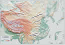
Four Major Plateaus |
 |
|
Qinghai-Tibet Plateau: |
Qinghai-Tibet Plateau: Situated in southwest China, it is the largest plateau in China, covering 2.5 million square km, or nearly a quarter of the national total land area. With an elevation averaging between 4,000 and 5,000 meters, it is the highest plateau on earth, and is known as the "roof of the world". Surrounded and traversed by several mountain ranges, the Qinghai-Tibet Plateau is where many of China's major rivers originate.
|
|
Inner Mongolia Plateau: |
Inner Mongolia Plateau: The second largest plateau in China, it lies between 1,000 and 2,000 meters above sea level in north China. It has a gentle rolling terrain and vast grasslands, with some parts covered with uninhabited Gobi and deserts.
|
|
Loess Plateau: |
Loess Plateau: Surrounded by the Taihang Mountains on the west, the Qilian Mountains on the east, the Great Wall on the south and the Qinling Mountains on the north, it covers 580,000 square km and lies 1,000 to 2,000 meters above sea level. Crisscrossed with ravines and gullies, it has fragmented landforms due to long-term scouring of rainfall and streams.
|
|
Yunnan-Guizhou Plateau: |
Yunnan-Guizhou Plateau: Covering east Yunnan Province and most parts of Guizhou Province, it has an elevation of 1,000 to 2,000 meters. It has a terrain that descends from northwest to southeast and is covered with numerous mountain ridges, valleys and rugged landforms.
|