| Videos | • Latest |
|
• Feature | • Sports | • Your Videos |
GPS units aiding Australian farmers
 0 Comments


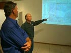
Satellite imaging technology pioneered by NASA is becoming a useful tool for Australian cattle farmers. They're using GPS units to keep an eye on their vast properties, with the click of a mouse.
Keeping track of a huge cattle station in Australia can mean driving around the property for several hours a day.
But for some farmers in Queensland, technology is now making the task a little easier through the use of satellite imagery.
With the help of a Global Positioning System, better known as GPS, this family now knows exactly what types of land exist on their property.
They can also use it to track how much feed and water is available to their stock at all times.
Simon Terry, Farmer, Howlong Station, Australia, said, "Even though we had a really good understanding of the country, (we had) lived here all our lives, it wasn't until you sort of had a helicopter view through the mapping process that we could understand it a lot better, especially the land types, and the complexity of the land types."
For farmers, the technology has not only been helpful in improving the way they manage their land, it has also been an engaging tool to spark interest in the next generation of cattle raisers.


Comments