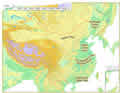
Major
plains in China: the Northeast China Plain, the North China Plain, the
Middle-Lower Yangtze Plain, the Pearl River Delta Plain and the Hetao
Plain.
Northeast
China Plain
Northeast
China Plain Situated in northeast China, the plain lies between the Greater
and Lesser Hinggan and Changbaishan mountains. Covering 350,000 square
km, it is China's largest plain. With most of it having an elevation of
lower than 200 meters, it embodies the Songhuajiang-Nenjiang-Heilongjiang
Plain, Songliao Plain and Liaohe Plain.
North
China Plain
North
China Plain Bordering on the Taihangshan Mountains in the west, the coast
in the east, the Yanshan Mountains in the north and the Huaihe River in
the south, the plain covers 300,000 square km, with an average elevation
of lower than 100 meters. Formed of alluvial deposits from the Yellow,
Huaihe and Haihe rivers, it is also known as the Yellow River-Huaihe-Haihe
Plain. It has a smooth terrain and vast fertile land.
The
Middle-Lower Yangtze Plain
The
Middle-Lower Yangtze Plain Stretching eastward from Wushan Mountain to
the coast, the plain was formed of alluvial deposits from the Yangtze
River and its tributaries. With an average elevation of lower than 50
meters and part of it lying below 5 meters above sea level, it is generally
lower than the North China Plain. Crisscrossed by many rivers and dotted
with lakes, it is known as "a swampy region."
Pearl
River Delta Plain
Pearl
River Delta Plain Situated in the central-south of Guangdong Province,
the plain covers 11,000 square km, with an average elevation of around
50 meters. It has crisscrossing rivers and is dotted with isolated hills.
Hetao
Plain
Hetao
Plain Lying along the banks of the Yellow River in the Inner Mongolia
and Ningxia Hui autonomous regions, the plain covers 24,800 square km,
with an average elevation of around 1,000 meters. Rich in irrigation facilities,
it is known as "the northern frontier resembling the south of the
Yangtze."